![]()
![]()
|
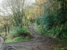
Cliffe Park Ridge and Furrow Horton Former mediaeval ploughing system, indentations visible on pasture land. Horton |
|
 |
Consall Forge Kilns Against the canalised River Churnet stands a bank of four large limekilns, dating from the early 19th Century. They were linked to a plateway built between 1815 and 1819 that ran from the Caldon Canal to north of Caverswall. Coal was brought in on the plateway from a number of local collieries, whilst lime was carried to Weston Coyney and beyond. By 1840 the line was out of use, although it is unclear precisely when the kilns ceased operation. Consall |
 |
Consall Plateway Former plateway dated c 1841 constructed to assist the transportation of burnt lime from Consall to Rangemoor. The line closed in 1849. Shown on the Ordnance Survey as 'Rail Road'. SJ96884718 Consall |
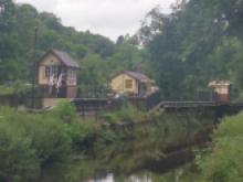 |
Consall Station Set in a picturesque hamlet deep in the Churnet Valley, Consall is the railway's "jewel in the crown". Sharing the valley floor with both the Caldon Canal and the River Churnet, this sleepy rural station is full of Victorian charm having been carefully restored to how it original was on its opening in 1902. Caldon Canal, Consall |
|
Copper Works Froghall The site of a copper and brass woks, built by the Bolton Company in 1890. The emphasis was on electrolytic copper production and manufacture but some work on complex brass alloys including aluminium brass was carried out there. Kingsley |
|
 |
Cross, Church of St John the Baptist, Alton A listed mid 19th century churchyard cross situataed to the east of the Church of St John the Baptist. The ashlar cross has a square base with three steps up to a pedastal with panels containing the symbols of the Evangelists. The shaft has a shield to each face and an elaborate head surmounted by a foliated cross. SK07344245 Alton |
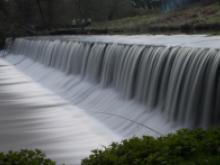 |
Crumpwood Weir Crumpwood Weir was built between 1807 and 1811 to take the Uttoxeter Canal across the River Churnet. Boats dropped through the nearby Carrington's Lock to join the river before being pulled across the top of the weir and back into the canal via Churnet Flood Lock on the south side. This lock was normally left open but had double sets of gates, as water levels could be lower or higher on the river than on the next section of canal towards Denstone. Canal, Listed structure |
|
Dairy House, Horton Small semi-derelict 17th century country house and attached farm. The farmhouse has a date stone readibng 'IBM 1635' in the apex of the roof. No public access. |
|
 |
Deep Hayes Reservoir In 1847 because of a poor water supply to the growing population of the Potteries, the Staffordshire Potteries Waterworks Company was formed. It constructed works in 1848 at Wall Grange which included taking water from a spring at Ceres (St. Caena) well (up to 1.5 million gallons a day) and the building of Deep Hayes Reservoir to compensate the River Churnet for the loss of this water which served several mills downstream. The source of water from Wall Grange in 1849 became the first principal supply for Hanley, Burslem and Tunstall. Country Parks, Deep Hayes |
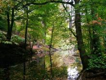 |
Dimmingsdale Owned by the Forestry Commission, Dimmingsdale is a very popular walking, riding and bouldering area. The landscape of Dimmingsdale has been shaped by the 15th century smelting industry and later by the 15th Earl of Shrewsbury, who built Alton Towers. Vehicle access and parking is along Red Road, next to the Ramblers Retreat tea room and gardens. Walking, riding and cycling access is via Staffordshire Way and over Lords Bridge on Churnet Way (Oakamoor to Denstone via Alton station) Alton, Dimmingsdale, Oakamoor |