![]()
![]()
|
Uttoxeter Canal (in Kingsley Parish) Part of the former route of the Uttoxeter branch of the Caldon Canal, which was built between 1808 and 1811. The canal was closed by 1849 to make way for the Churnet Valley Railway. Kingsley |
|
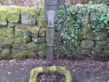 |
Village pump & trough, Alton A cast iron Victorian water pump and stone trough on Dimble Lane, Alton. Dated between 1865 and 1899. Listed designation. SK07224199 Alton |
 |
Wall, St John the Baptist Catholic Church A listed mid 19th century wall and outbuilding which enclose the north and west sides of the Catholic Church of St John the Baptist. SK07394246 Alton |
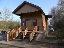 |
Waterhouses Goods Shed This was the transhipment shed between the narrow gauge Manifold Valley line on the left and the standard gauge North Staffordshire branch to the right. It now houses a cycle hire business at the start of the Manifold Trail. |
 |
watering troughs, on plateways Supposedly water troughs used by the horses pulling the limestone wagons on one of the old plateways from Froghall to Cauldon. |
|
Watermeadow at Dunwood The earthwork remains of a post-mediaeval water meadow system fed by Horton Brook. Identified from aerial photography in the area to the north-west of Dunwood. Upstanding earth works with carriers appear to survive as earthworks across 10-50% of the total area of the meadow. Longsdon |
|
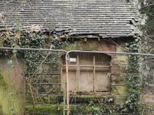 |
Weighing office This dilapidated building just off the main road by the old mill at Alton on the disused railway track used to the weighing office, built by North Staffordshire Railway as part of the set of buildings that formed Alton Station. There used to be a wooden grain store next to it. It is currently owned by the same company that owns Alton Towers and has more recently been used to store props or costumes. |
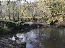 |
Weir for Alton Mill Leat We were sent this photo the weir for the Alton Mill Leat by Keith Thomkins to use in our Facebook Friday photo challenge and here is what he says about it: Alton, Churnet, Dimmingsdale, Oakamoor |
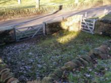 |
Whiston Pinfold The pinfold was restored by a group of local volunteers from Kingsley Parish with help from a CVLLP grant. The pinfold has been in existence since mid 19th century, used as an enclosure for stray animals. Volunteers dug it out and removed a century of tipped rubbish, in particular a lot of interesting glass bottles. They restored the dry stone walls and planted the surrounding area with daffodil bulbs. whiston |
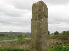 |
Windyway Cross This standing stone is called Windyway Cross, on Ipstones Edge (SK05814897). It was set up to guide packhorses over the hills from the copper mines of Ecton down into The Churnet Valley. It marks a safe route over Ipstones edge, in between the boggy bits, on the track from Ecton copper mine to Whiston Smelter. Its tall, finger-like shape could be spotted from miles around. The Whiston Smelter needed more coal than it did copper, so it made sense to position the works nearer the coal fields than the copper mine. Dating from 1882, it replaced one from 1770. |